Site Selection
For me, finding this site was simple: I spent 3 months living there during the summer after my freshman year. My dorm was closed, and a friend offered me an affordable sublet just across the street from the Broadway Red Line stop. Of course, I accepted her offer and spent the summer noticing that this region of Boston is a very interesting place. Its main attraction is the diversity of its urban landscape and the activities within it. The site includes buildings that are commercial, residential, commercial/residential, and industrial, with a healthy dose of transportation infrastructure. There is new development (I spotted four active housing projects on my last visit) and unoccupied properties (including at least one boarded up house). There is no consistent, or even prominent, architectural style or building size. Frankly, the inconsistency of the area is part of what makes it so attractive to study.
While it was hard to narrow down a site within this area, I eventually settled on a (still rather large) segment bordered by 4th St. to the south, B St. to the east, and 2nd St./Traveler St. to the north. I considered bounding my site at Dorchester Ave. to the west, but really wanted to include the rail yard and the edge of the interstate, so I extended the western boundary just across the Bass River.
Dorchester Ave. draws a sharp dividing line through the site. Running north-south, the street cuts off an amorphous area to the west from a rough northeast-southwest grid pattern to the east. Beneath the street itself lies the Red Line. Just across from the Broadway stop, taking up the full block between 4th & Traveler lies a massive pair of condo buildings, each with quasi-subterranean parking complexes. Beyond this lies an MBTA rail yard (where the Red Line trains come to sleep) and a commuter rail track.
Crossing the bridge at either Traveler or 4th leads directly beneath the concrete pillars of the interstate overpasses. The noise in this corner is constant and grinding: the screeching of trains, the humming and thudding of cars across the overpass, the buzzing and clanking of construction. I wonder if the din affects the property value of the condos? In fact, I have a number of questions about these condos. They are the only two buildings on the west side of Dorchester Ave. that are residential. They are huge, upscale buildings, and obviously required a lot of land to build. How did the developers acquire that much land for one project? Did the land come from the MBTA? What was there before? I don't know how old these buildings are, but they appear to be in good condition and generally conform to what I would assume to be modern. I plan to investigate them further.
On the other side of Dorchester, to the east, is The Grid. I had already noticed, while perusing maps of my site, the gridiron-and-break structure which Grady discusses at length in "Close Up: How to Read The American City," but I couldn't deduce its cause. While visiting my site, I discovered the answer: the grid runs parallel to another rail line. My whole site is actually built over this line, which runs along the South Boston Bypass (signs clearly indicating “commercial vehicles only”) and the numerous bridges crossing it are so well built into their surroundings that I'd never noticed them before. I am very curious about how this structure came to be. I would guess that the commercial road used to be additional tracks, but what caused the two-tiered development of the neighborhood in the first place? Was the track dug into a ditch or was the surrounding area built up over it?
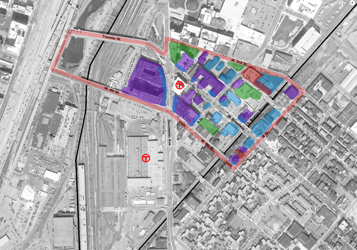
Wandering further, the site is a jumble of residential and commercial development. The included map (fig. 1) shows a rough estimation from my observations of the primary uses of the building within the site. A common feature of many residential building is ground-floor commercial space. These spaces are found occupied with everything from cycle studios, laundromats, coffee shops, bars and liquor stores, and a veterinary hospital. Otherwise, the area's buildings share very little in common. Some are new, some are refurbished. Some are triple-deckers with a tiny footprint, some take up entire blocks. One was once a cathedral, now condos. Their lots appears neither consistently sized nor arranged in any meaningful pattern. Is there an underlying method to this madness? Will I be able to make sense of this site? I certainly hope so.
This site is more interesting for its inconsistencies. So much of it is different and I have no idea what forces caused it to develop this way. I'm excited to continue my investigation and figure out what shaped this bizarre section of Boston.
| Color | Meaning |
| Red | Unoccupied/For Lease |
| Purple | Residential |
| Blue | Commercial/Industrial |
| Green | Current Development |
| Black | Rail Lines |
Bibliography
Clay, Grady. "Close Up: How to Read the American City." The University of Chicago Press: Chicago, IL, 1980: pp. 11-16, 38-65.
"Boston, MA." Map. Google Maps. Google, 2018. Web.
"West Broadway, Boston, MA." Map. Google Maps. Google, 2018. Web.

